Mountain Snows, Cooler Temps On The Way
Your SAWX forecast for the week of November 18
Welcome to Stone Age WX [SAWX], a five-day forecast I post every Sunday. As a life-long sky-watcher I love discussing the weather, and since the U.S. National Weather Service [NWS] provides public-domain forecasting models from which to work, I will dive into this project with relish each week.
My goal here is to present fresh, unique takes - without any agenda one way or the other - to make weather FUN again. After all, in a world where there is so much division, the one thing we ALL share, whether we believe in ‘climate change’ or ‘climate manipulation’… or neither?
Weather. We all have it, we all discuss it. So… let’s do just that…
The chill has returned to the Mountain West, and with it a taste of snow as well. Amounts could be heavier in higher elevations, but in most cases you’re looking at no more than 6 inches total. While this level of accumulation might send cities in the deep south into a panicked state, in states like Montana, Wyoming and Idaho? It is barely a blip. Just fire-up your safe-snow practices (and maybe some fresh-cut logs for warmth and relaxation), and you’ll be good to go.
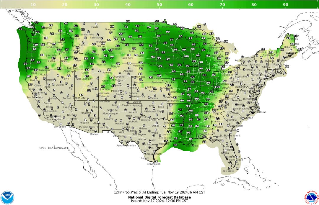
On the rainfall front, a large system of moisture stretching northeast from the Rio Grande into Wisconsin is in play Monday, with severe storms, dangerous winds, and tornadic activity possible in much of central Oklahoma south into western-to-central Texas. This system will continue to expand and move east throughout the week, with the Mississippi Valley in the cross hairs on Tuesday.
While rains are possible (some locally heavy) in the deep south and Appalachia on Wednesday, it will be the Upper-Great Lakes west into North Dakota which have the largest threat of storms (the latter of which possibly seeing snows as early as Tuesday).

Thursday has this system squatting around the Great Lakes, Ohio Valley, and the entire northeastern tier, where is is expected to loiter through the end of the work week. This could also result in a light blanket of snow in south-central Ohio and the Appalachian Mountains, Thursday night into Friday.
The rest of the nation (not in the mountain west) will be enjoying relatively mild-to-warm temperatures for the first part of the week, so if the skies are favorable? Touch grass and enjoy it… because the chill is coming. Indeed, by Wednesday the north-central tier of the nation will see highs the 30s and 40s, and by Friday said-highs will stretch into the Mid-Atlantic and New England states.
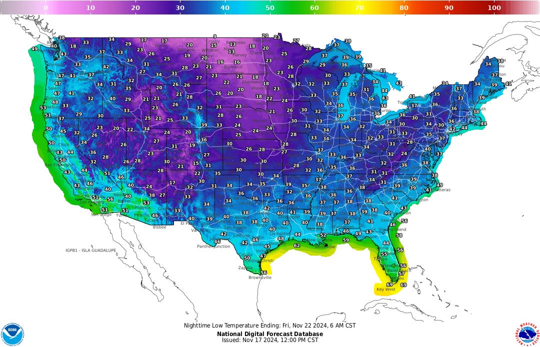
Naturally, this is going to cause some chilly low temperatures. While the entire mountain-west will be in the deep freeze all week long, starting Wednesday night those lows start to grab the rest of the country, to the point that - by Thursday - the overnight forecast map will be saturated in blues and purples.

The Pacific Northwest is once again an active weather spot this week, which is par-for-the-course this time of year. The upper elevations of the Cascades are once again expecting to get pounded with snow throughout the week, where the total accumulations forecast could be measured in feet instead of inches.
Meanwhile, west of the range from Bellingham into Northern California (with the Puget Sound and the Willamette Valley especially being in the bullseye), it will be raining. A lot. Again. Some of these could be heavy, so if you’re not a big fan of umbrellas you may want to rethink your strategy.
Or… just get wet. Y’all are pretty much used to it anyhow, and since higher winds are also expected (making the hand-held shelters essentially useless)… why not?
And that’s all for this edition of SAWX. I hope you enjoyed this exclusive of The Stone Age, and until next week: Be in the now, look up, and stay weather-aware.
Thank you for your continued support, and - if not already a subscriber - join me as we build a unique Substack subculture of information, entertainment, and enlightenment. Also consider becoming a paid Member, for additional content and other shenanigans!
Notes…
-- I am not a meteorologist; I am merely a weather enthusiast who loves discussing all things related to weather. As such, these forecasts are for entertainment purposes only.
-- To gather accurate, up-to-date forecasts for your area, or in the event of a weather-related emergency, always check with your local weather sources, your favored weather app, or listen in to your weather radio.
-- All information presented here is based on data gleaned from the National Weather Service, and is thus public domain.
-- Unless otherwise credited, all images were generated by the author, using Grok 2 or Substack’s AI Image Tool.


Another fine post. The rain has been a bit more intense these last couple days in St. Helens, Oregon and the temps have reached into the mid 30's causing the lovely fall colors to jump off the trees. The steady steely grey skies and dismal slop will resume on schedule thus keeping a lot of those Commiefornians from moving here.
I am enjoying your weather sharings.
They remind me weather forecasts in the 60’s 70’s 80’s
They were
Forecasts, Not Predictions 😊
Grateful
Ellen
🕊️💖🙏