Pacific NW Rainy Season In Full Swing
Your SAWX forecast for the week of November 11
Welcome to Stone Age WX [SAWX], a five-day forecast I post every Sunday. As a life-long sky-watcher I love discussing the weather, and since the U.S. National Weather Service [NWS] provides public-domain forecasting models from which to work, I will dive into this project with relish each week.
My goal here is to present fresh, unique takes - without any agenda one way or the other - to make weather FUN again. After all, in a world where there is so much division, the one thing we ALL share, whether we believe in ‘climate change’ or ‘climate manipulation’… or neither?
Weather. We all have it, we all discuss it. So… let’s talk about it here…
The seasonal (and months-long) rainy season in the Pacific Northwest is at full strength, beginning in the overnight hours tonight (Sunday). For vast swath of areas which lie west of the Cascades in Washington and Oregon, moisture is being forecast in the 80%-100% range.
The rains are predicted to last throughout the work-week ahead, and will stretch south into northern California and east into western Montana no later than Wednesday night. While expected to be steady, few-to-none are expected to be hazardous.
Staying in that part of the country, starting Monday night the Cascade Mountains are expecting snowfalls, some of which are forecast to be heavy. Lasting at least through Wednesday morning, higher elevations could be looking at well over a two feet of accumulation once it is all said and done.
Fresh powder will also blanket parts of the northern Rockies starting Monday afternoon, and is expected to be persistent. The Colorado Rockies are also getting a fresh covering, with snow moving in Tuesday afternoon; it should be finished by early-morning Wednesday, however, and have no affect on the Front Range.

Getting back to the rain, there is a wide-ranging band of precipitation being forecast for Wednesday night in Thursday, covering nearly all of the central section of the country which sits along - and east of - the Mississippi River. They anticipate this will break-up as it moves northeast, and should largely dissipate by Friday morning.
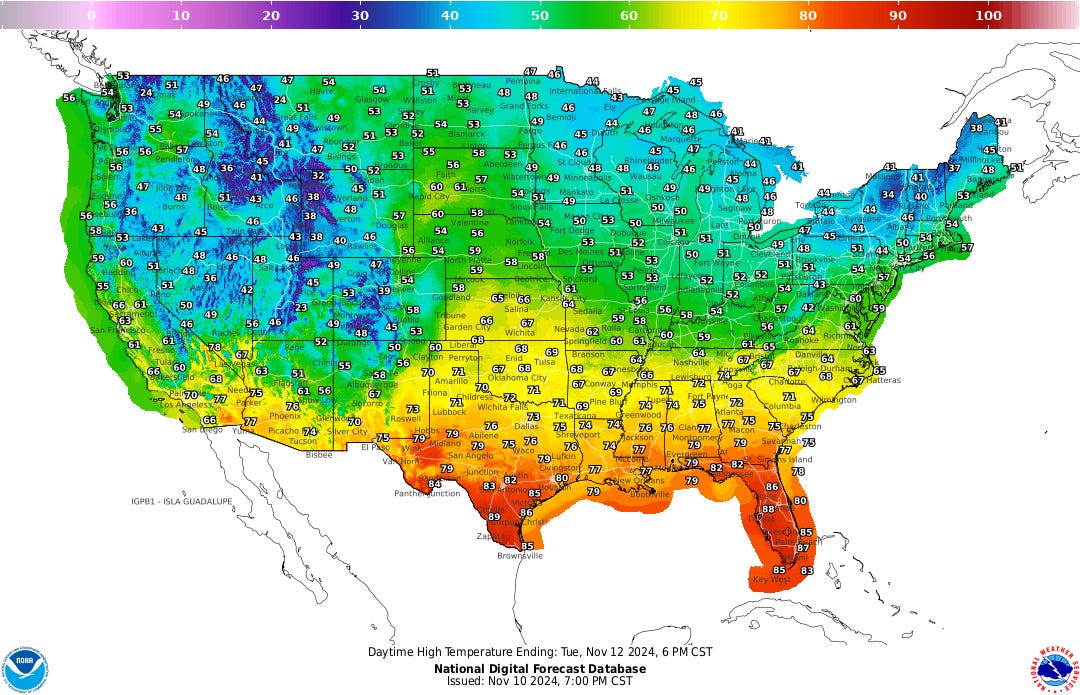
Meanwhile, temperatures across the country are relatively seasonal, although our friends in Florida and southern parts of Texas are expecting above-average numbers throughout the week. Furthermore, lows are not mass-dropping into the sub-freezing range in the Mountain West as yet, which is not normal for mid-November; this is something I will continue to track.
One other exception to the seasonal expectations is in the northern parts of New England, especially Maine; while November lows usually average near-to-around freezing, Thursday morning you could wake in temps in the teens. Those lows will be warmer the following night, however, and conditions should be back to normal by Saturday.

One other curious hiccup is in the Desert Southwest, where on Thursday forecast highs are expected to warm slightly, with it getting up to 10°F hotter in select locations. That is not expected to last, however, as highs are expected back into the high-70°s across the region by the next day.
And that’s all for this edition of SAWX. It is a little ironic that my launch of this weekly feature happens to land on a week where there is very little diversity in conditions and temperatures, but sometimes things just work out that way. As we are entering the winter season soon, however… who knows what is to come.
I hope you enjoyed this exclusive of The Stone Age, and until next week… look up, and stay weather-aware.
Thank you so much for reading, and for the subscriptions, ‘likes,’ comments, and restacks. It all plays a vital role in sustaining and growing The Stone Age, thus I value each of you.
Notes…
-- I am not a meteorologist; I am merely a weather enthusiast who loves discussing all things related to weather. As such, these forecasts are for entertainment purposes only.
-- To gather accurate, up-to-date forecasts for your area, or in the event of a weather-related emergency, always check with your local weather sources, your favored weather app, or listen in to your weather radio.
-- All information presented here is based on data gleaned from the National Weather Service, and is thus public domain.
-- Unless otherwise credited, all images were generated by the author, using Grok 2 (on X) or Substack’s AI Image Tool.


This is more fun!
Bring the rain down here now. C’mon!!