Stone Age WX: A Web-Only Drop
Weather forecast for the weekend of September 14-15, 2024
Let’s talk about the weather.
Welcome to Stone Age WX, a weekend weather forecast offered to you every Friday evening as a Web-Only Drop. While am I not any sort of expert on the subject, as a life-long weather-geek I love talking about it, while (hopefully) presenting fresh, unique takes - without any agenda one way or the other.
I know, I know - you have a smartphone which gives you access to forecasts for your area with a tap of your finger. What is lacking from those auto-generated outlooks, however, is personality… along with a sense of connectivity.
After all, in a world where there is so much division, the one thing we ALL share, whether we believe in ‘climate change’ or ‘climate manipulation’… or neither?
Weather. We all have it, we all discuss it.
So… let’s do just that…
Stay informed of full-length articles, TDT drops, and more! Join me as a subscriber today!
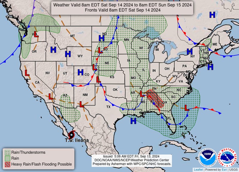
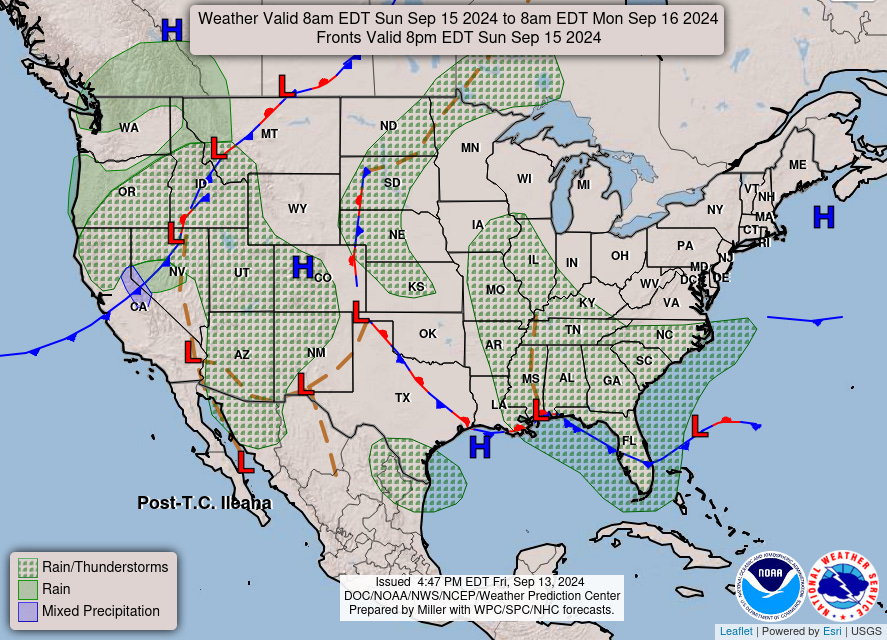
Rain is a predominant feature this coming weekend, as remnants of two oceanic events (Francine from the Gulf of Mexico, Ileana from Baja California) stir up some moisture-rich conditions, with thunderstorms possible.

Francine’s effects will be the more severe, as she continues to wreck havoc on both the Lower Mississippi and Tennessee Valleys, along with most of the southeast. Heavy rain is likely in those regions, with severe storms and flash flooding not an impossibility; thankfully, it appears any tornadic threat will have been mitigated by Saturday.
As for what is left of Ileana, she is rolling up the Baja into New Mexico and Arizona over the next two days. Folks in the region should be on the lookout (especially Sunday) as the tropical event will be able to drop locally heavy rainfall, bringing about the potential for isolated flash-flooding.
Oh, and also? The Pacific Northwest will see rain… because of course it will.

As for temperatures? Basically… if you are not getting rain, you are probably getting heat. Like, 10°-15°-above-average-in-some-areas heat.
Most of the (dry) middle of the country will be in the high 80°s to low 90°s, while in Texas some locales will be reaching for triple-digits (I don’t think it will actually reach those numbers… but it will be trying to). Another area under threat of above-average warmth is the Ohio Valley region, stretching as far east as Pennsylvania.
The good news about all this? The nights are cooling off considerably in these areas, with temps dipping into the lower 60°s and even the high 50°s. So - at least after the sun goes down - September is still somewhat behaving as September.
That’s all I got for now; if you have thoughts (or are a weather-geek like me), feel free to share your weather conditions and forecasts in the comments below. Thank you as always for reading, and have a great weekend!
To support these Web-Only drops, and my efforts to take ‘The Stone Age’ to new heights…
Notes…
-- I am not a meteorologist; I am merely a weather geek who loves discussing all things related to weather. As such, these forecasts are for entertainment purposes only.
-- To gather accurate, up-to-date forecasts for your area, or in the event of a weather-related emergency, always check with your local weather sources, your favored weather app, or listen in to your weather radio.
-- All information presented here is based on data gleaned from the National Weather Service, and is thus public domain.
-- Unless otherwise credited, all images were generated by the author, using Grok 2 (on X) or Substack’s AI Image Tool.


I've been hoping Ohio would cool down some during the day. Dang.
Texas: Alexa is going to tell me it got to the triple digits, everything else will say it didn’t. Or the exact opposite.