


Dangerous 'Great Lakes' Snows Continue
Your SAWX forecast for the weekend of December 6-8

Welcome to Stone Age WX [SAWX], a weekend forecast I post every Friday. As a life-long sky-watcher I love discussing the weather, and since the U.S. National Weather Service [NWS] provides public-domain forecasting models from which to work, I will dive into this project with relish each week.
My goal here is to present fresh, unique takes - without any agenda one way or the other - to make weather FUN again. After all, in a world where there is so much division, the one thing we ALL share, whether one believes in ‘climate change’ or ‘climate manipulation’… or neither?
Weather. We all have it, we all discuss it. So let’s talk about it here, agenda-free…

Our friends along the Great Lakes have been getting hammered with lake-effect snows over the past few days, with accumulations being measured in feet in some areas. These look to continue into Saturday night, especially in upstate New York, Pennsylvania, and the northeastern corner of Ohio.
Those snows will shift east on Saturday night into Sunday, with much of northern New England (especially Maine) getting a decent blanket of the white stuff. Maine will also see dangerously cold overnight temperatures, with lows in the single-digits both Friday and Saturday.
Meanwhile, it’s going to be wet across most of central and eastern Texas pretty much all weekend, with slight rain-potentials into Arkansas and Louisiana as well. Said-potentials spread east and north as Sunday afternoon approaches, with the lower Mississippi Valley expecting rains into the evening. These could be locally-heavy, with some areas forecast to get up to a half-inch.

Speaking of moisture, showers and a few high-elevation snowfalls are returning to the Pacific northwest by Saturday, with chilly rains in and around the Puget Sound being prominent. The snows, which will stretch into much of the northern Rockies throughout the weekend, should remain within seasonal norms, with no major weather-events anticipated from them.
We are also expecting patchy-to-heavy fog in southwestern Idaho and in the San Joaquin / Sacramento Valley Friday evening, with a small section of southwestern Wyoming possibly being affected in the overnight hours. These fogs will dissipate before noon Saturday, though they could briefly return to the California valleys Saturday night into the AM hours Sunday.
Overnight cold snaps are expected for the much of the Old South both Friday and Saturday nights, with lows dipping below freezing across the region from Georgia into Louisiana. Daytime temperatures will be chilly as well, with highs up to 10° below normal.
But… there is a warm-up coming… and it’s gonna be sweet.

Indeed, much of the western US will be basking in temps well-above normal, with areas from Oklahoma into Montana reaching the 50°s and 60°s by Saturday; that is nearly 20° above average for this time of the year. As it expands east it should drive the chill-bugs out of the south, allowing Sunday to be most pleasant for a good portion of our Republic.
The southwest will also enjoy a warmer trend Saturday, with 60°s (and a few 70°s) stretching from (most of) southern Arizona into a large swath of California. That pattern is expected to hold up through Sunday as well, with a few areas being 10° above normal.
After the chilly blast most of us have been experiencing, it will be nice to get a few roastier temps - well, roastier for this time of year, anyhow. So if your conditions allow, take a moment to touch grass this weekend, even if it is a little brittle; after all, January is not that far off, and when it arrives?
For many Americans, ‘grass’ will not be an option again until spring…
And that’s it for this edition of Stone Age WX; I hope you enjoyed this exclusive of The Stone Age. Until next week: Be in the now, look up…
… and stay weather-aware.
Thank you for your continued support, and - if not already a subscriber - join me as we build a unique Substack subculture of information, entertainment, and enlightenment. Also consider becoming a paid Member, for additional content and other shenanigans!
Important Note
Regular consumers of SAWX may have noticed that there is a lot of red on the temp map, and may be thinking ‘Whoa - that’s toasty!” While there IS a warm-up occurring (and a fairly significant one), the National Weather Service also updated its color-schemes for temperatures; they do this twice a year, to keep up with the seasonal changes.
So while the last SAWX had this for the legend…
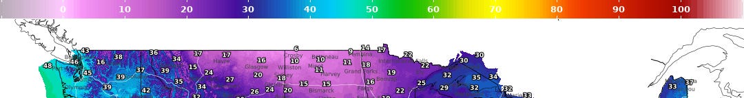
.. this week’s has this…

Just an FYI.
Notes…
-- I am not a meteorologist; I am merely a weather enthusiast who loves discussing all things related to weather. As such, these forecasts are for entertainment purposes only.
-- To gather accurate, up-to-date forecasts for your area, or in the event of a weather-related emergency, always check with your local weather sources, your favored weather app, or listen in to your weather radio.
-- All information presented here is based on data gleaned from the National Weather Service, and is thus public domain.
-- Unless otherwise credited, all images were generated by the author, using Grok 2 or Substack’s AI Image Tool.
I am looking forward to Florida warming back up again. The Iguanas fall from the trees when it gets too cold here, and it has been, in my opinion, far too cold! But, at least there's no more hurricanes for a while 😅 Great Lakes area though.. what the hell. I didn't know this was going on. TY for update.
I will check into Weatherman Plus and the space weather to see if any of this "makes sense". My friends in WNC and central NC all had snow yesterday and day before, which they said was NOT forecast. I suspect incessant geoengineering and chemical spraying is making things spaz, for lack of proper terminology.
Salute to you Stone.
California live tsunami coverage! https://www.youtube.com/live/5bwW6T63iJ0